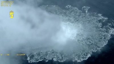
Nord Stream – Anatomy of Dante’s Explosion

All Global Research articles can be read in 51 languages by activating the Translate Website button below the author’s name.
To receive Global Research’s Daily Newsletter (selected articles), click here.
Click the share button above to email/forward this article to your friends and colleagues. Follow us on Instagram and Twitter and subscribe to our Telegram Channel. Feel free to repost and share widely Global Research articles.
***
Abstract
Even months after the demolition of the Nordstream Pipelines it is a widely held opinion that the pipelines were destroyed with a moderate explosive of a few hundred kilograms TNT corresponding to a seismic event of (Richter-) Magnitude 2.3 and that the destruction of the pipeline was the only goal of that act.
An overview over publicly available seismic data all over Northern Europe shows that this could not be farther from the truth: Seismic traces were detected as far as the North Cape (1800km) and Greenland, thus characterizing the Nordstream explosion as a teleseismic event.
An analysis of the waveforms detected at seismic stations around the Baltic and Bothnian Sea characterizes this event to have (‘body-wave‘) magnitude mb = 3:9 +/- 0:15, corresponding to a detonation energy of 200 tons TNT-equivalent or more rather than the 500kg claimed in the press. The actual explosive power involved in the detonation is thus at least by a factor of 400 larger than what has been claimed in the press.
The resulting waveforms reveal little resemblance with conventional underwater explosions, but they share characteristics with known underground nuclear explosions. The explosive was positioned along the pipeline at a deliberately chosen location such that the generated shock wave was channeled and amplified by a natural oceanic canyon of approx. 20km width which runs from the detonation site towards Kaliningrad (RF).
Indeed, in neighbouring Polish Suwałki seismic amplitudes were registered that were 1000-fold of what is expected from a magnitude 3.9 event at that distance from the epicentre. Infrared satellite images of aerosols taken a few hours after the explosion show a cloud extending over more than a hundred kilometers into the Swedish mainland in wind direction while the adjacent coastal town of Karlskrona exhibited brief spell of mild rainfall in the following hours. Hydrodynamic satellite data show the emergence of a strong underwater current near the ocean floor (at 60m depth) away from the explosion site accompanied by significant backflow in the following hours. The topography of the ocean floor exhibits a natural, elliptically shaped depression of about 50km size and the explosive was placed close to the focal point. Such an arrangement is well known to be responsible for strong focussing effects of shockwaves towards the underwater channel directed towards Kaliningrad. This explains the extraordinary seismic amplitudes detected along that direction as registered in Suwałki.
These facts point towards a controlled and carefully prepared attack not only on Nordstream but also on the Russian exclave of Kaliningrad.
Contents
Contents
I. Prologue
II. Seismic Considerations
1. Introductory Remarks
2. Seismic Data of the Nordstream Explosions
III. Hydrodynamic Considerations
IV. Atmospheric signature – aerosol coverage in the infrared
V. Conclusions
VI. Epilogue
References
Appendix — Focusing effects of shock waves
Click here to read the article.
*
Note to readers: Please click the share button above. Follow us on Instagram and Twitter and subscribe to our Telegram Channel. Feel free to repost and share widely Global Research articles.
Featured image is from Seymour Hersh

